
What We Provide
US Utility Potholing provides subsurface utility engineering to ASCE 38-22 across South Florida and beyond. We cover the field side of SUE — designating and Quality Level A test holes, delivered as mapping — so one company is accountable for what ends up on the drawing.
What a SUE scope with us includes:
QL-B Designating
Electromagnetic locating and ground penetrating radar to establish horizontal position in the field.
QL-A Test Holes
Vacuum-excavated to expose the utility and measure true depth, outside diameter and material.
Utility Mapping
CAD, KMZ and PDF deliverables with every line attributed by the Quality Level it was established at.
Survey Control
Sub-inch GPS on every designated alignment and measured point, tied to your project control.
Depth is only ever certified at QL-A. Anything above that is horizontal position, and we label it that way.
What Is Subsurface Utility Engineering?
Subsurface utility engineering (SUE) is a branch of civil engineering that manages risks associated with underground utilities. SUE combines geophysical investigation, vacuum excavation, and engineering judgment to provide project teams with reliable, survey-grade data about the location, depth, and condition of buried utilities before and during construction.
Unlike a standard utility locate — which marks approximate horizontal positions based on electromagnetic signals — SUE follows a structured, ASCE 38-22 quality level framework to deliver quantified, defensible data that engineers can use in design documents, conflict analysis reports, and subsurface utility engineering plans.
At US Utility Potholing & Air Excavation, we provide full SUE support services in South Florida, including ground penetrating radar (GPR) scanning, vacuum excavation and daylighting, private utility locating, and utility mapping with survey-grade coordinates — everything your engineering team needs to meet ASCE 38-22 requirements for designated and measured utility data.
ASCE 38-22 Quality Levels Explained
The ASCE 38-22 standard defines four quality levels for characterizing subsurface utility data. Each level builds on the previous, increasing accuracy and eliminating uncertainty about utility position and depth.
Quality Level D (QL-D) — Existing Records
QL-D is the entry-level quality level and relies solely on existing utility records, GIS data, as-built drawings, and utility owner records. This level provides a broad picture of what utilities are known to exist in an area but carries the highest uncertainty. Utilities that were never documented, relocated, or abandoned without record will not appear in QL-D data. QL-D is typically the starting point for early project scoping.
Quality Level C (QL-C) — Surface Evidence
QL-C supplements the record research of QL-D with field surveys of visible surface evidence — valve boxes, manholes, clean-out caps, utility markers, power poles, and other appurtenances that confirm a utility's existence and general location. QL-C data is still horizontal-only and carries uncertainty, but it validates or corrects record data using observable field conditions.
Quality Level B (QL-B) — Geophysical Designation
QL-B is the most commonly required quality level for design-phase utility studies. It involves active geophysical investigation — primarily GPR scanning and electromagnetic (EM) pipe-and-cable locating — to designate the horizontal position of buried utilities. QL-B data is marked on the ground surface, photographed, and tied to survey control. The result is a utility plan showing the expected horizontal path of each detected utility with far greater confidence than record data alone.
QL-B does not establish depth. Depth uncertainty remains, and design teams must account for that uncertainty in their conflict analysis.
Quality Level A (QL-A) — Physical Daylighting
QL-A is the highest quality level and eliminates depth uncertainty entirely. It requires physically exposing a utility at a specific location using vacuum excavation (hydrovac or air excavation) and collecting precise survey measurements for both horizontal position and top-of-pipe depth. QL-A test holes, also called potholes or daylighting holes, are documented with photographs, field measurements, and survey-grade coordinates that can be incorporated directly into design models and conflict reports.
QL-A is required at locations where a design element — drainage pipe, bridge footing, directional bore path, or utility crossing — has a conflict risk with a subsurface utility. FDOT and other DOT agencies routinely require QL-A data at identified conflict points as a condition of construction plans approval.
What Subsurface Utility Engineering Services Include
Subsurface utility engineering is not a single task. It is a sequence, and each stage produces a different grade of data. In practice our SUE work breaks into three things we do on site: designating, potholing, and mapping.
Utility Designating — Finding What Is There
Designating is the geophysical stage: locating and marking the horizontal position of buried utilities across the project footprint. We run electromagnetic induction to trace conductive and tracer-wired facilities, and ground penetrating radar alongside it on every project to catch what EM cannot see — PVC water, HDPE gas, empty conduit, concrete storm. This produces Quality Level B data: reliable horizontal position, marked in paint and flags on the ground.
Designating answers where. It does not answer how deep, and any SUE provider who tells you otherwise is overselling a locator reading.
Utility Potholing — Verifying Depth
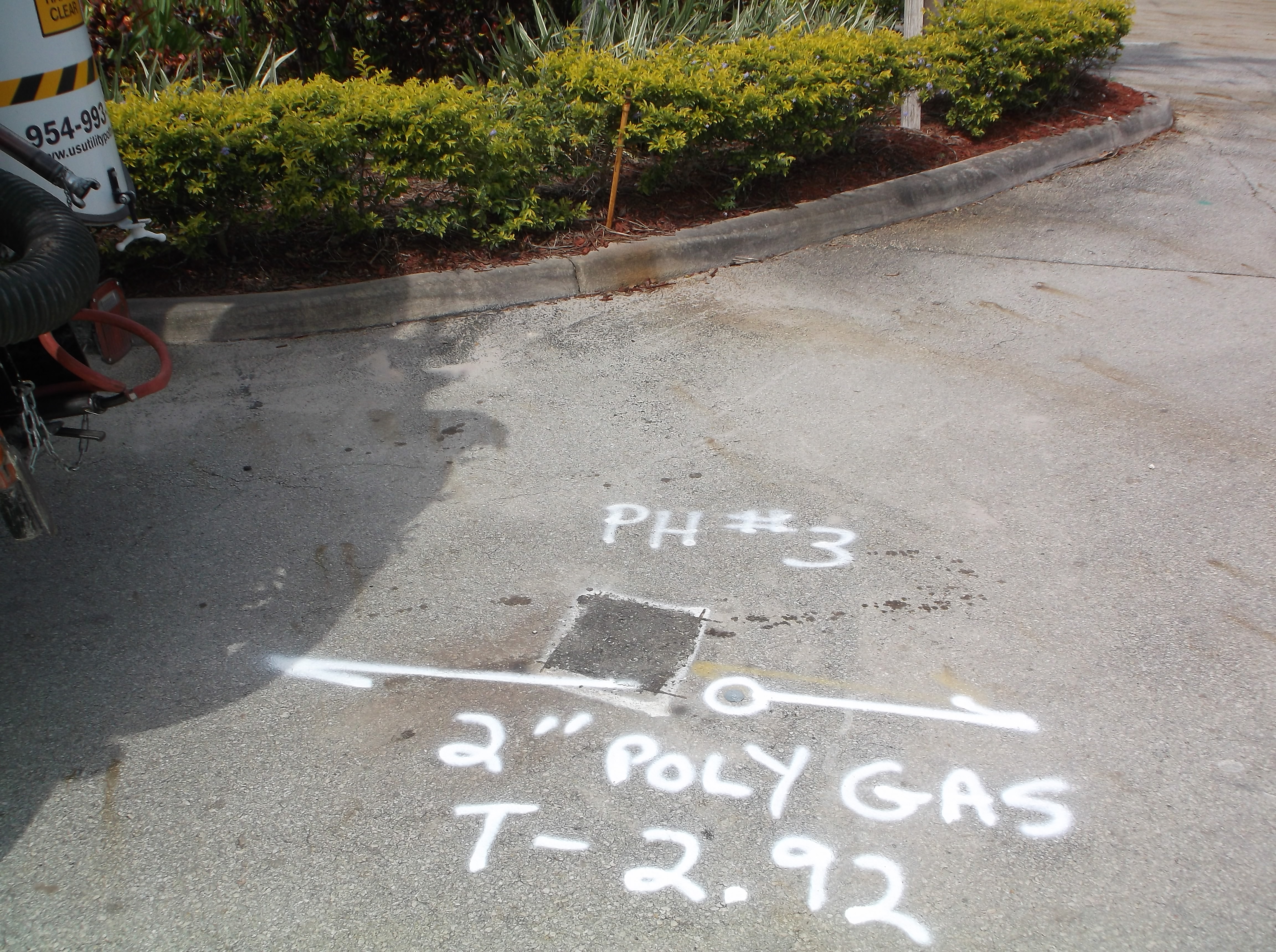
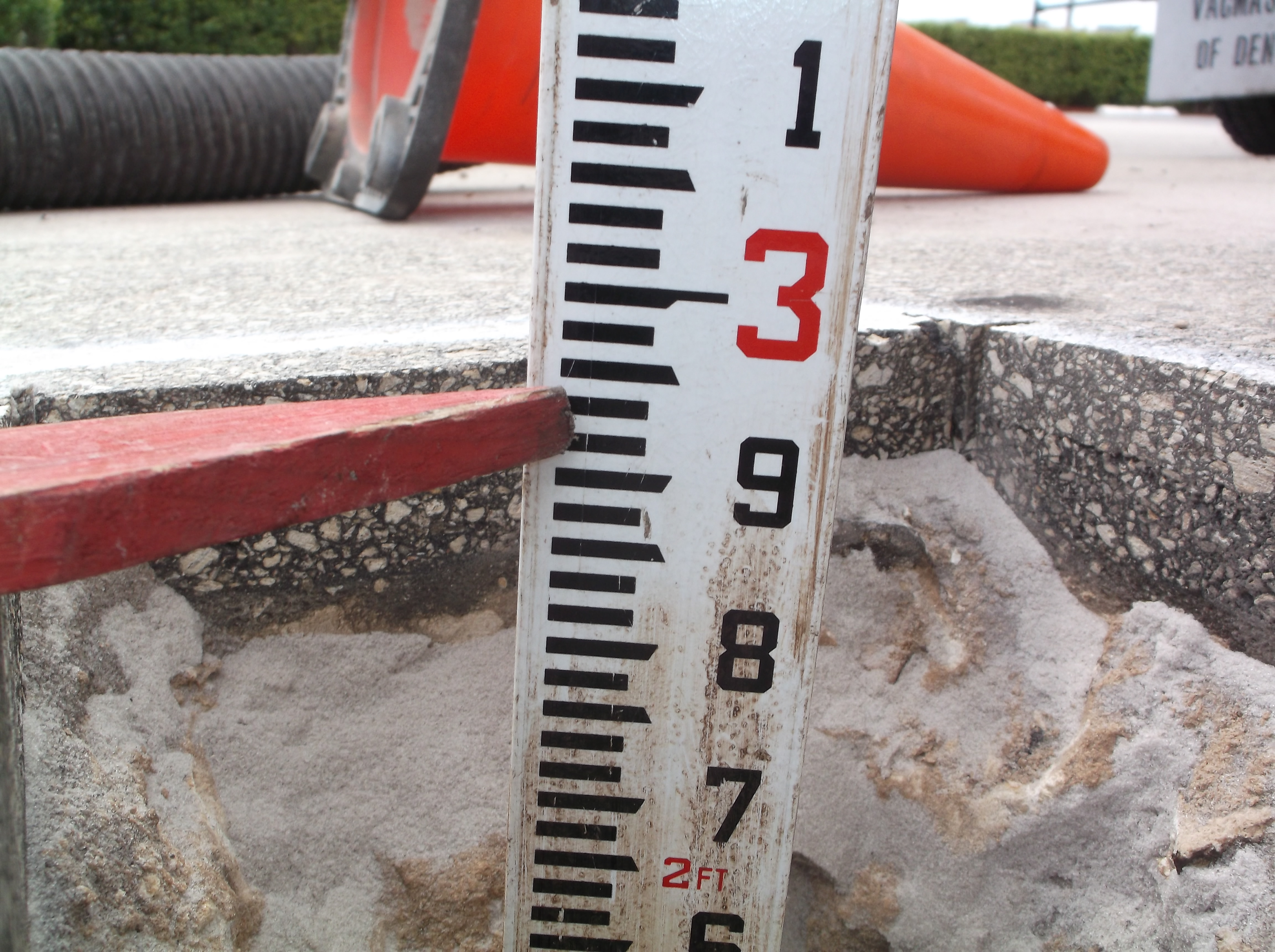
Potholing is the physical stage. Using vacuum excavation, we expose the utility at the specific points your design has to clear, then measure depth to top of pipe, outside diameter and material directly off the pipe. That is Quality Level A — the only grade of data in ASCE 38-22 that comes from seeing the utility rather than inferring it.
On most projects a small number of well-chosen test holes resolves the conflicts that actually control the design. We work with the engineer to pick those locations rather than potholing indiscriminately.
Utility Mapping — Turning Field Data Into Deliverables
Field marks wash away. Mapping is what survives. We capture designated alignments and test hole positions with sub-inch accurate GPS and deliver them as a KMZ overlay for Google Earth alongside CAD and PDF, with each utility labeled by the Quality Level it was established at.
That labelling matters more than it sounds. A drawing that shows every utility at the same apparent confidence is how conflicts survive into construction. Our utility mapping deliverables state what was verified, what was designated, and what came from records — so your reviewers can see the difference.
Choosing Among Subsurface Utility Engineering Companies
Most subsurface utility engineering companies will quote the same quality levels, because the levels are defined by a standard rather than by the provider. What differs is how the field work is actually performed, and that is worth asking about directly.
Three questions separate providers quickly. Are you direct-connecting to utilities, or transferring marks from record drawings onto the ground? Is GPR included on every project, or billed as an extra when EM comes up short? And will the deliverable label each utility by Quality Level, or present records-based lines at the same weight as exposed ones?
We answer those the same way every time: connected where there is an access point, GPR on every project at no extra charge, and Quality Levels stated per utility. Where a line cannot be resolved — no tracer wire, nothing to connect to — we mark it as unknown rather than guessing. An honest unknown tells your crew where to dig carefully. A confident wrong line does the opposite.
Why Engineers and DOT Projects Require SUE
Utility conflicts are the single largest source of construction change orders on underground infrastructure projects. A utility struck during excavation can halt an entire job site for days while emergency repairs are made, utility owners respond, and work plans are revised. In South Florida's dense utility corridors — particularly along US-1, I-95, I-595, and Broward and Palm Beach Boulevard alignments — the risk of encountering undocumented or mislocated utilities is significant.
FDOT's utility accommodation manual and Federal Highway Administration guidance both recommend or require SUE on roadway design projects above certain cost thresholds. SUE has been shown to return $4 to $10 in avoided costs for every $1 spent — primarily by finding and resolving conflicts during design rather than construction.
For civil engineering firms preparing 30%, 60%, and 90% design submittals, SUE data provides:
- Defensible utility conflict identification for permit submissions
- Accurate depth data for clearance calculations on horizontal directional drilling and microtunneling
- Verified utility positions for drainage and underground stormwater system design
- Documentation required by FDOT utility certification letters
- Reduced exposure to utility damage claims and construction holds
How US Utility Performs SUE in South Florida
Our SUE workflow combines the geophysical and vacuum excavation capabilities your project needs at each quality level:
QL-B Designation
Our field crews deploy dual-frequency electromagnetic locators, ground penetrating radar systems, and passive scan methods to designate utility corridors within your project limits. All detected utilities are marked on the ground surface, documented with GPS coordinates, and delivered in a format compatible with your survey control. We work directly with your project surveyor or can coordinate with licensed surveyors to tie QL-B data to project datum.
QL-A Test Holes
Where your conflict analysis identifies QL-A locations, we mobilize our vacuum excavation equipment to expose the utility at the designated point. Our air excavation and hydrovac units can work in pavement, landscaped areas, and open ground without damaging the utility or surrounding infrastructure. Each test hole is documented with top-of-pipe depth, pipe diameter, material (where visible), and horizontal offset from a known reference. Photographs and field notes are provided with every test hole, and we coordinate with your surveyor for final survey-grade coordinate collection.
After survey, test holes are backfilled and compacted to your project specifications. Temporary pavement patching is available on request.
Who Needs Subsurface Utility Engineering?
SUE services are relevant for a wide range of project types and clients throughout South Florida:
- Civil engineering firms preparing design documents for roadway, drainage, and underground utility projects
- FDOT prime contractors and design-build teams fulfilling utility engineering contract requirements
- Airport project contractors working within FAA-controlled airspace utility corridors at FLL, MIA, and PBI
- Utility owners (water, sewer, electric, telecom, gas) planning new installations in congested corridors
- Municipalities and counties in Broward, Miami-Dade, and Palm Beach planning capital improvement projects
- Private developers with underground parking structures, deep foundations, or infrastructure crossings
- Horizontal directional drilling contractors needing bore path clearance verification before steering
SUE in South Florida's Utility Environment
South Florida's utility infrastructure is among the most congested in the Southeast. Decades of growth in Broward, Miami-Dade, and Palm Beach counties have layered telecommunications, water, sewer, electrical, gas, and stormwater infrastructure at every depth from surface to more than 20 feet. Many of these utilities predate modern record-keeping and appear nowhere in GIS databases.
High water tables — often within two to four feet of the surface — affect burial depths and push utilities closer together. The sandy, high-conductivity soils common across South Florida can limit electromagnetic locating depth, making GPR an essential complementary tool. Our crews are trained on South Florida ground conditions and deploy the right combination of geophysical tools for each project corridor.
We serve projects throughout the region, including Pompano Beach, Fort Lauderdale, Hollywood, Miami, Hialeah, Coral Gables, Boca Raton, Delray Beach, West Palm Beach, and all surrounding communities in Broward, Miami-Dade, and Palm Beach counties.
What does a subsurface utility engineering company actually do?
A SUE provider establishes where buried utilities are and how reliable that information is, graded to ASCE 38-22. In practice that means three things: designating (marking horizontal position geophysically with EM and GPR), potholing (exposing a utility to measure depth to top of pipe directly), and mapping (delivering the result with each utility labeled by the Quality Level it was established at).
Is utility mapping included in subsurface utility engineering services?
Mapping is the deliverable stage of SUE and is quoted alongside the field work. We capture designated alignments and test hole positions with sub-inch accurate GPS and deliver them as a KMZ overlay for Google Earth plus CAD and PDF. Field paint is temporary; the mapped data is what your design team and reviewers keep.
Can you do SUE designating without potholing?
Yes. Designating alone gives you Quality Level B — reliable horizontal position across the site, which is enough for many early-design and clearance purposes. You only need potholing where the design has to clear a utility vertically, because depth can only be measured from an exposed pipe. Many projects buy QL-B across the footprint and QL-A at a handful of conflict points.
Do you provide SUE across all three South Florida counties?
Yes — Broward, Miami-Dade and Palm Beach counties, with coverage extending into Collier, Lee and St. Lucie. Each county has its own utility owners and permitting expectations, so we have county-specific pages covering how SUE work is handled in each.
Subsurface Utility Engineering by County
Each county has its own utility owners, permitting expectations and field conditions. These pages cover how SUE work is handled in the three counties we serve most:
- Subsurface Utility Engineering in Broward County — QL-B designating and test holes across the dense urban corridors.
- Utility Mapping in Miami-Dade County — mapped deliverables and coordination across multiple utility owners.
- Subsurface Utility Engineering Services in Palm Beach County — the design-phase workflow from records research to QL-A.
- Subsurface Utility Engineering in Fort Lauderdale — dense downtown and port corridor work.
- Subsurface Utility Engineering in Boca Raton — campus, corporate park and post-tension concrete conditions.
Request SUE Services
If your project requires ASCE 38-22 SUE quality level services — from QL-B designation through QL-A daylighting and test holes — contact us to discuss scope and scheduling. We work directly with engineering firms, DOT contractors, and project owners to deliver the data your project needs on time. Request a quote or call us at (954) 849-2859.
Frequently Asked Questions
What are the ASCE 38-22 SUE quality levels?
ASCE 38-22 defines four quality levels: QL-D uses existing utility records only; QL-C adds surface evidence such as valve boxes and visible markers; QL-B uses geophysical methods like GPR and electromagnetic locating to designate horizontal utility positions; QL-A involves vacuum excavation (daylighting) to physically expose utilities and collect survey-grade horizontal and vertical coordinates.
What is Quality Level A (QL-A) in subsurface utility engineering?
QL-A is the highest level of ASCE 38-22 and involves physically exposing a utility via vacuum excavation or potholing and collecting precise survey-grade coordinates for both horizontal position and depth. QL-A data eliminates depth uncertainty and is required on projects where utility conflicts could cause major delays or safety hazards.
When do FDOT and DOT projects require SUE?
FDOT and most state DOT agencies require SUE — typically QL-B as a minimum with QL-A at identified conflict zones — on roadway widening, bridge, drainage, and underground infrastructure projects. SUE is required during the design phase to identify and resolve utility conflicts before construction begins, reducing change orders and project delays.
How is GPR used in subsurface utility engineering?
Ground penetrating radar (GPR) is a primary QL-B geophysical tool used during SUE. GPR transmits radar pulses into the ground and detects reflections from buried utilities, voids, and other subsurface features. Combined with electromagnetic locating, GPR provides the most complete picture of underground utility positions without excavation.
Related services: confirming horizontal and vertical position in the field · hiring a private locator · the rest of our capabilities
Pricing: see what utility potholing costs per test hole in South Florida.