Utility Locating in Fort Lauderdale's Dense Urban Environment
Fort Lauderdale presents some of the most complex underground utility environments in Florida. As Broward County's seat and largest city, Fort Lauderdale has layers of utility infrastructure built over decades — from mid-century water and sewer mains to modern fiber optic conduit, FPL underground distribution, and private developer-installed systems that often have little or no documentation.
The downtown core along Las Olas Boulevard, the I-95 corridor, Broward Boulevard, and the Flagler Village and Tarpon River neighborhoods all contain dense, overlapping utility networks where a single mislocated line can cause costly delays, utility strikes, and safety incidents. Our private utility locating service gives contractors and engineers the accurate underground information they need before the first shovel hits the ground.
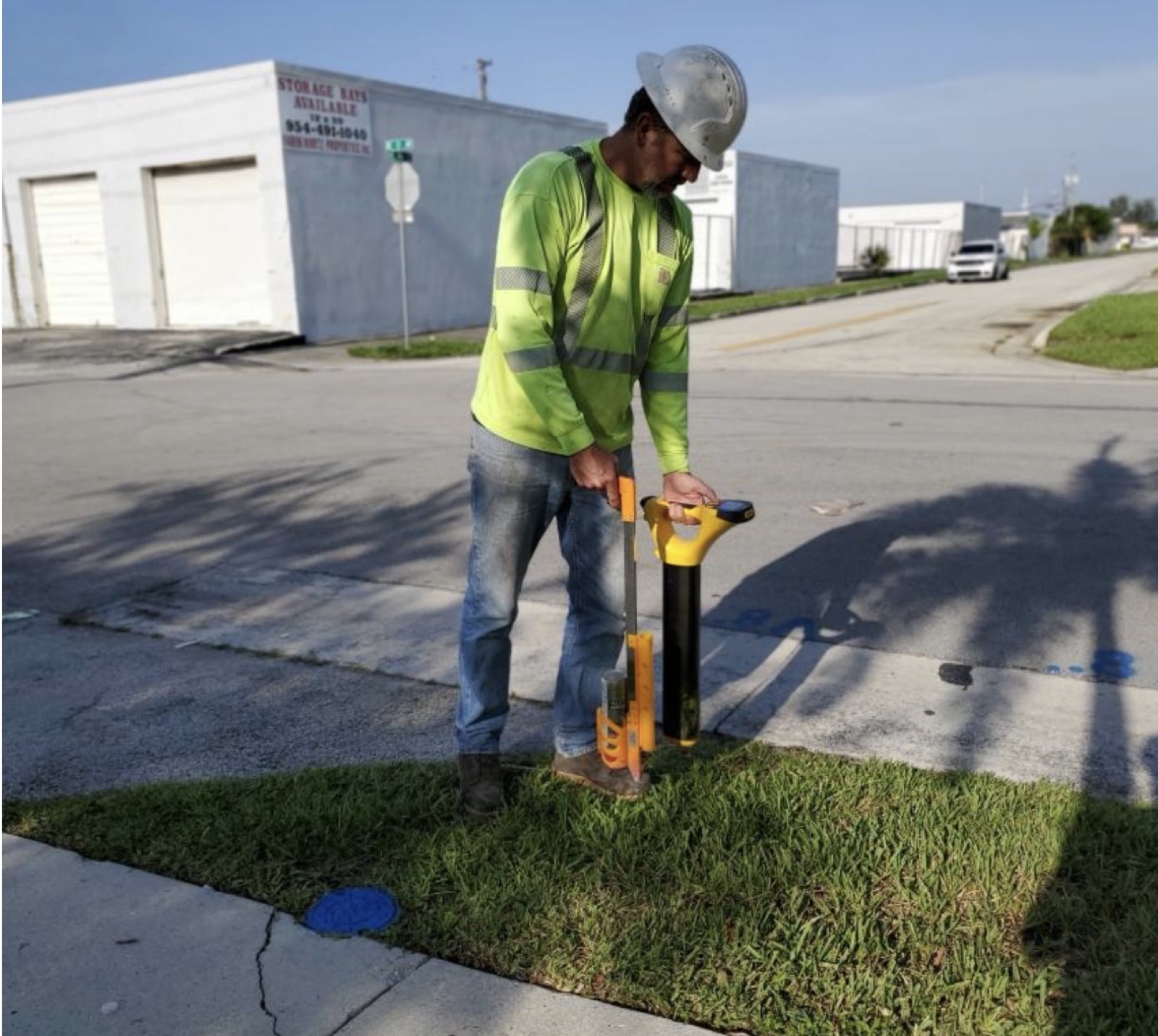
GPR Scanning in Fort Lauderdale
Fort Lauderdale's utility density makes Ground Penetrating Radar (GPR) an essential complement to standard electromagnetic locating. While EM equipment excels at tracing conductive utilities like metallic pipes and live electrical, GPR detects non-conductive infrastructure — HDPE water mains, concrete drainage, abandoned conduit, and voids — that EM cannot identify.
Our GPR scanning service is widely used on Fort Lauderdale projects involving downtown redevelopment, right-of-way improvements on state roads like SR-736 (Davie Boulevard) and SR-842 (Broward Boulevard), and site work near Fort Lauderdale-Hollywood International Airport (FLL), where utility congestion from decades of airport expansion creates significant subsurface complexity.
Utility Potholing & Vacuum Excavation — Fort Lauderdale
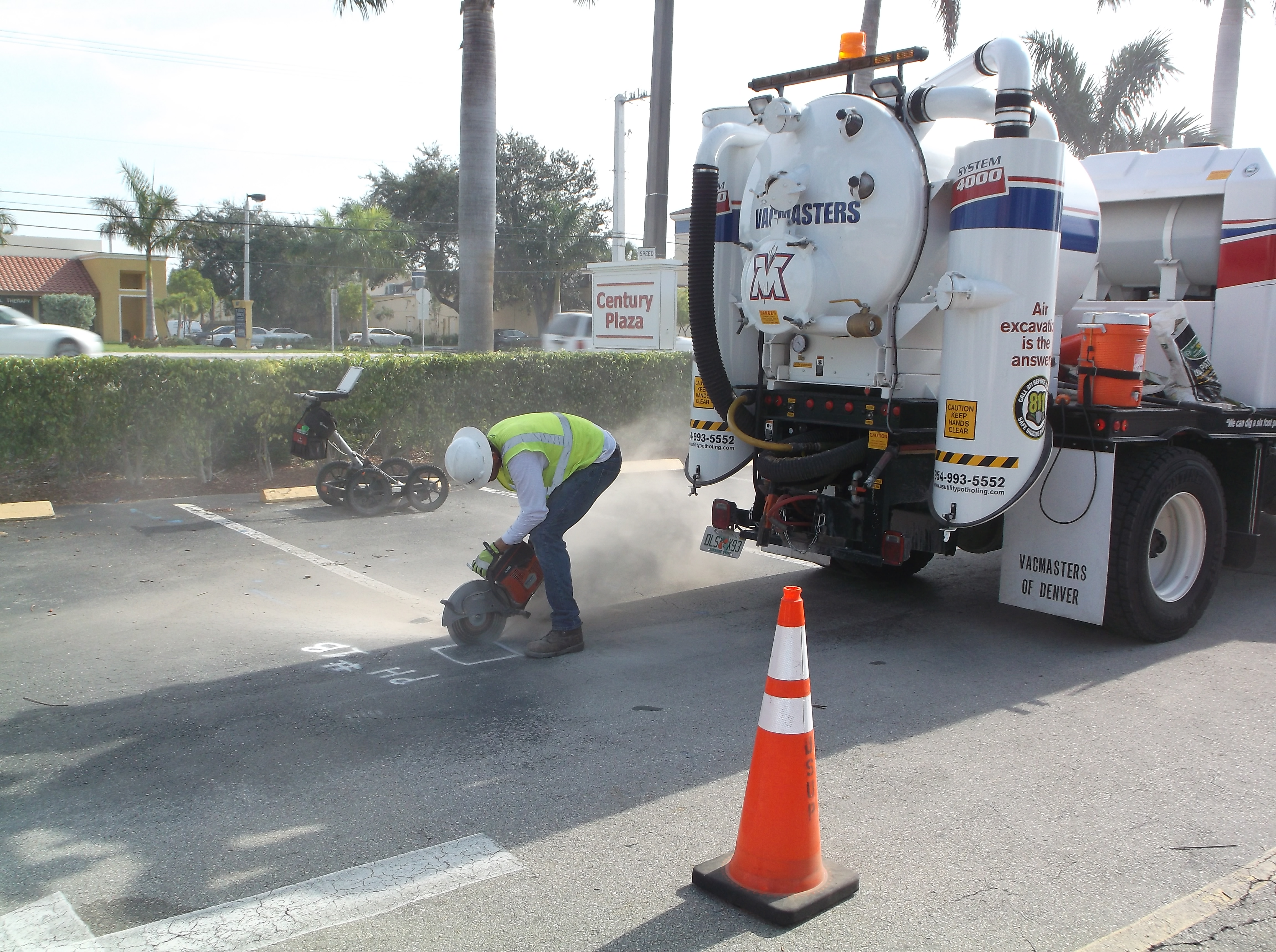
When a utility conflict is identified on your Fort Lauderdale project, the next step is utility potholing to confirm the exact depth, position, and condition of the conflicting utility. Our vacuum excavation trucks create safe, precise test holes — hydrovac or air — that expose the utility without the risk of mechanical damage from backhoes or trenchers.
Fort Lauderdale's FDOT District 4 (D4) projects along I-95, US-1 (Federal Highway), and US-441 (SR-7) frequently require formal SUE Quality Level A designating before construction begins. We provide potholing services that meet FDOT and ASCE 38-22 documentation requirements, including photographed, measured, and reported utility exposures that your project engineer can rely on for design decisions.
Fort Lauderdale Service Areas
We serve all of Fort Lauderdale, including downtown, the Las Olas corridor, Flagler Village, Victoria Park, Tarpon River, Riverside, Colee Hammock, and the neighborhoods along I-95, US-1, and Broward Boulevard. We also serve the areas surrounding FLL Airport, Port Everglades, and the industrial zones along SR-84 and Griffin Road that are technically within Fort Lauderdale's urban service area.
As part of our full Broward County service area, Fort Lauderdale projects benefit from our regional knowledge, established relationships with local utility owners, and fast response times from our Pompano Beach headquarters.
Utility Potholing in Fort Lauderdale — Why It Matters Here
Fort Lauderdale is one of the most utility-intensive construction environments in Florida. As Broward County's urban core and regional center, Fort Lauderdale's underground infrastructure reflects decades of dense development — layers of electrical duct banks, water and sewer mains, telecom conduit, private utility systems, and drainage infrastructure are compressed into right-of-way corridors that have been modified repeatedly over 70+ years of construction.
For contractors and engineers working in Fort Lauderdale, utility potholing is not a luxury — it is a necessity. The dense, multi-generation utility environment means that a paint mark on the pavement represents significant uncertainty: utilities in Fort Lauderdale are commonly off-plan, shallower than records indicate, or accompanied by adjacent undocumented utilities that were installed at the same time but never recorded. Physical exposure through vacuum excavation potholing is the only way to confirm exactly what is underground at your conflict locations.
US Utility Potholing is based in nearby Pompano Beach and works Fort Lauderdale projects regularly. We know the city's utility corridors, the relevant utility owners, and the City of Fort Lauderdale's requirements for potholing and excavation work in the right-of-way. That local knowledge means faster project setup, fewer surprises, and more efficient field operations on your Fort Lauderdale construction project.
Fort Lauderdale Potholing — Key Project Areas
Our Fort Lauderdale utility potholing work spans the full geographic range of the city:
- Downtown Fort Lauderdale: The Flagler District, Andrews Avenue corridor, and Federal Highway through downtown carry extreme utility density. HDD and utility work in the downtown core requires potholing at every significant utility crossing.
- Las Olas Boulevard: Fort Lauderdale's premier commercial corridor has been reconstructed multiple times. Potholing on Las Olas regularly reveals utilities at unexpected positions and depths relative to as-built records.
- I-95 and Broward Boulevard corridor: The interchange area and Broward Boulevard from I-95 east to downtown is a major utility corridor for water, sewer, and utility transmission infrastructure. FDOT projects in this area frequently require QL-A potholing.
- FLL Airport area: The Fort Lauderdale-Hollywood International Airport and surrounding commercial development require utility verification for all underground construction and utility upgrade work.
- Port Everglades: Infrastructure work at Port Everglades requires utility potholing to navigate the complex underground environment of one of Florida's largest seaports.
- US-1 (Federal Highway) and Dixie Highway: These north-south arterials carry decades of layered utility installations and are frequently the subject of potholing for FDOT, Broward County, and private developer projects.
The Potholing Process — Fort Lauderdale
Our utility potholing process in Fort Lauderdale follows a consistent, professional workflow designed to produce reliable results and minimize disruption to your project and the surrounding area:
We begin with a review of available utility records and your project plans to identify the priority pothole locations — typically the points where your proposed excavation, bore, or installation crosses or comes within close proximity to a known or suspected utility. If utility locating has not already been performed, we can perform EM and GPR locating on the same mobilization as the potholing work, reducing cost and schedule.
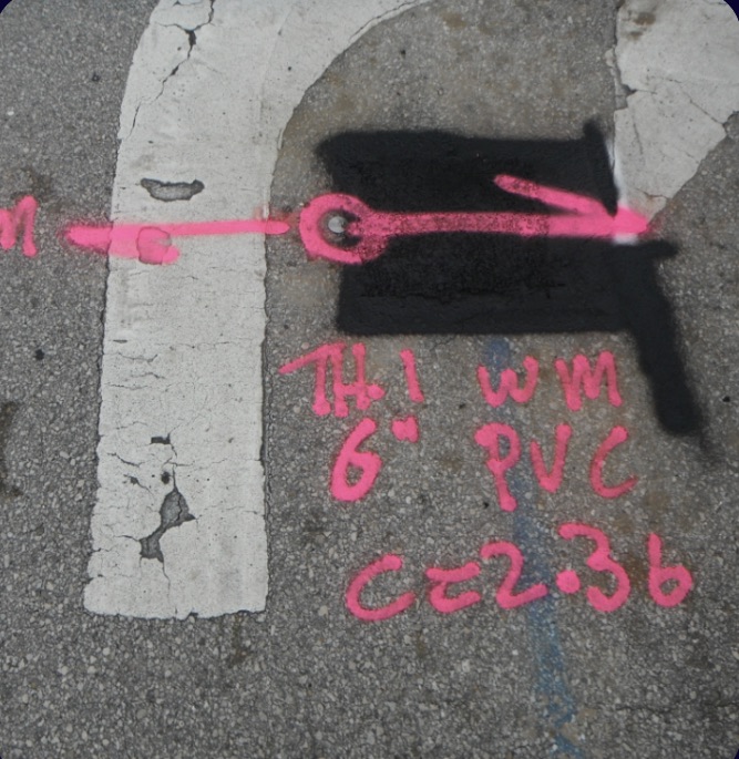
At each pothole location, our crew marks the surface, saw-cuts the asphalt or concrete where required, and uses the vacuum excavation truck to remove soil in a controlled, precise operation. We work down to the utility level, exposing the pipe or conduit without mechanical contact. Once exposed, we record the utility's horizontal position, depth-to-top, depth-to-invert, material, diameter or dimensions, and condition. We photograph the exposed utility with a depth rod in the frame and document all findings in writing.
Test holes are backfilled with sand and temporary patching following completion. Permanent pavement repair can be arranged if required by the City of Fort Lauderdale or FDOT permit conditions. We provide all field documentation needed for inclusion in your project records, engineer deliverables, or FDOT SUE reports.
For more information on our potholing services and methods, visit our utility potholing page. For broader Fort Lauderdale utility services, see our Fort Lauderdale service page.
Decades of Layered Installation Under the Downtown Grid
The downtown street grid has been dug, backfilled, resurfaced and dug again for most of the city's history, and each cycle added facilities without removing what came before. Mains were replaced in place or re-routed around new structures, electric distribution moved underground in sections rather than all at once, telecom arrived in waves with each carrier building its own path, and drainage was rebuilt to serve a grid that sits low against the New River and the Intracoastal. The practical result is that a cluster shown as one annotation on a plan is often several separate facilities at different offsets and different depths, some abandoned in place and indistinguishable on paper from the lines still in service.
Owner records are where a Fort Lauderdale scope gets planned and also where it stops being reliable. Owner records vary in age, datum and accuracy, relocations made during past roadway and bridge work were not always recorded back to the original drawing, and services running into individual buildings are frequently missing altogether. We review what the owners hold to plan the work, but a records product is not a field result and we do not issue one as a deliverable. We designate the full work limits geophysically, because on a downtown block the facilities that cause problems are usually the ones no drawing shows.
Designating in a Signal-Saturated Street Grid
Downtown Fort Lauderdale is a difficult electromagnetic environment. Continuous rebar and wire mesh in slabs and pavement, structural steel on high-rise sites, metal drainage structures, rail in and near the corridor and dense duct banks all return signal, and a single-method sweep in that setting produces marks that look confident and are not. Electromagnetic induction needs a conductive path and a point to connect to. Where a facility is accessible we energise it directly and trace it, which is the most reliable result the method can give. Where no connection point exists, or where parallel conductors share a trench and couple together, an induced trace can follow the wrong one and then jump to another.
That is why ground penetrating radar runs on every project here alongside EM rather than being sold separately. GPR sees what EM cannot: PVC and HDPE conduit without tracer wire, non-metallic water services, abandoned lines carrying no current, vaults and the edges of a duct bank envelope. It has its own limits. On the low blocks near the New River and the Intracoastal, salt influence and a shallow water table cut useful penetration, and any depth a radar profile reports depends on how fast the signal travels through the soil, which is not constant as the water table moves. Where the two methods disagree, the deliverable says where they disagree rather than averaging them into one confident line.

Telecom and Fiber Duct Banks in the Business District
The downtown business district carries a concentration of telecom that most corridors in the county do not. Several carriers serve the office towers, and the paths they built are layered the way everything else downtown is layered: conduit added alongside conduit, some encased in concrete as a duct bank, some direct-buried, much of it non-metallic with no tracer wire to put a signal on. A duct bank is not a line. It is an envelope with a width, a top and sometimes a lower tier, and marking it as a single alignment under-represents what a bore or an open cut will meet. Building laterals are harder again, because past the point of service they are private and outside 811. We designate the bank with EM where a traceable element exists, define its edges with GPR, and put a test hole on it when a crossing or a bore profile depends on knowing the top elevation instead of estimating it.
Highway, Rail, Port and Airport Corridors
Work along I-95, US-1 and Federal Highway, Broward Boulevard, the FEC corridor through downtown and the Tri-Rail corridor alongside I-95 puts a design team into rights-of-way where the owner's alignment is only half the information. Longitudinal installations parallel the roadway for long runs and then turn without a record, and crossings under highway and rail are usually bored, so their depth profile has little to do with the cover on either side. Designating establishes the horizontal picture across the corridor segment, and the crossings that control the design get test holes. We vacuum excavate with a vac truck, or with air and barrel soft dig where the surface has to stay intact, and record top-of-pipe elevation, outside diameter, material and position on sub-inch accurate GPS. That is Quality Level A: a measured point, not an interpretation of a signal.
The industrial and terminal properties around Port Everglades and the airport add private systems on top of the public ones. Terminal, cargo and support facilities carry their own electrical distribution, fire and process water, drainage and communications behind the point of service, and none of that is something 811 dispatches a member locator for. Private utility locating covers it. Access and disturbance often govern in these areas as much as the utilities themselves, and vacuum excavation suits that: the excavation is the footprint of the hole, the surface is cored and patched in kind, and lanes and yard areas stay in service around it.
Frequently Asked Questions — Fort Lauderdale
Can you perform utility locating on FDOT right-of-way in Fort Lauderdale?
Yes. We regularly perform utility locating and potholing within FDOT District 4 right-of-way in Fort Lauderdale and throughout Broward County. We are familiar with FDOT maintenance of traffic (MOT) requirements, FDOT utility accommodation policy, and the documentation standards required for FDOT D4 projects. We work alongside general contractors, engineering firms, and FDOT-approved construction managers on right-of-way utility clearance and SUE designating assignments.
How does GPR scanning help on Las Olas Boulevard redevelopment projects?
Las Olas Boulevard and the surrounding downtown Fort Lauderdale core have highly layered utility infrastructure from multiple generations of installation. GPR scanning helps identify utilities that are not in any available record drawings — including abandoned conduit, old water mains that were not decommissioned, and non-metallic pipes that EM locating cannot detect. Combining EM locating with GPR provides the most complete picture of what's underground before redevelopment excavation begins.
Do you offer emergency utility locating in Fort Lauderdale?
Yes. For active utility strikes, unexpected utility conflicts, or time-critical excavation situations in Fort Lauderdale, call us directly at (954) 849-2859. Our Pompano Beach base gives us a short travel time to Fort Lauderdale, and we prioritize emergency calls to keep your project moving safely. Standard response for non-emergency requests is same-day or next-day.
Related services: subsurface utility engineering in Fort Lauderdale · utility potholing and vacuum test holes in Fort Lauderdale · coverage across Broward County
Serving Fort Lauderdale from Pompano Beach
County: Broward County utility locating
Services in Fort Lauderdale: Private Utility Locating · Utility Potholing · Ground Penetrating Radar · Vacuum Excavation · Utility Mapping · Subsurface Utility Engineering