Boca Raton's subsurface utility engineering demand comes less from open highway corridors than from developed sites that are effectively private systems behind a single point of service. Florida Atlantic University's main campus, the office and research parks along Yamato Road, the commercial corridor where Glades Road meets I-95, the institutional properties spread through the city and the sites around Boca Raton Airport share a pattern: the utilities that matter to a project were installed by the property owner, extended piecemeal as buildings were added, and documented, where documented at all, in drawings that live with a facilities department rather than with a utility owner. A campus distribution loop, a private fire main, a site electrical duct bank or an irrigation network will not be marked by a member locator through 811, because 811 notifies member owners and those owners stop at the point of service.
US Utility Potholing performs subsurface utility engineering on Boca Raton projects: campus and institutional sites, corporate and office park properties, municipal utility work, commercial renovations and additions, and site development. We are licensed and insured, and we work for civil engineering firms, general contractors, municipalities and electric utility crews. Every project runs electromagnetic induction locating and ground penetrating radar together, with GPR included rather than billed as an add-on, because private site systems contain as much non-metallic pipe and untraced conduit as they do locatable conductors. Field positions are captured on sub-inch accurate GPS and delivered as a KMZ Google Earth overlay along with CAD and PDF, each utility labelled by its ASCE 38-02 quality level so a designated alignment is never read as a measured one.
Campus Distribution Systems and Where 811 Stops
A large campus behaves like a small municipality. It runs its own water and fire service, sanitary and storm systems, electrical distribution between buildings, communications, and often chilled water or other central plant distribution, all of it installed across successive building programs over decades. The drawings that exist are usually organised by building rather than by system, so a line is documented where it was installed and then disappears at the edge of that project's limits. Tie-ins, re-routes around later construction and temporary services that became permanent tend not to make it back onto anything. On a campus the missing information is not an edge case; it is most of the site.
Designating on a campus has one advantage over open right-of-way work: access. Valve boxes, pull boxes, handholes, pedestals and transformer pads give crews a point to connect to, and a direct connection produces a far more reliable trace than an induced signal. Where there is no connection point, or the facility is non-metallic, ground penetrating radar carries the work. Reinforced walkways, plazas, structured parking and dense conduit runs between buildings return enough signal that we treat a single-method result as provisional, and we reconcile EM against GPR before anything goes on the deliverable. The mapping that comes out of it is labelled by quality level and remains useful to the facilities group long after the project that paid for it.
Several Utility Owners on One Boca Raton Site
Record research in Boca Raton means going to more than one place. The city operates its own water and wastewater systems across much of its service area, so those records come from the city rather than from a county authority. Electric distribution, gas and the telecom carriers each hold their own. A university, hospital, office park or corporate property adds a private owner with its own drawings and its own conventions. Reclaimed and irrigation water is a further set again, and on larger properties it is usually PVC without tracer wire, which makes it a radar problem rather than an electromagnetic one.
We request from each owner, plot everything on one base and label it Quality Level D, because a compiled records drawing is still a records drawing no matter how many sources went into it. The place where record quality falls off is predictable: the meter, the backflow, the pad, the point of service. Public records generally stop there and private drawings generally start somewhere else, and the gap between them is where a design assumption goes wrong. Designating the full work limits closes that gap in plan view, and the crossings where elevation actually controls the design are the ones that get test holes.
GPR Scanning Before You Core a Post-Tensioned Slab
Post-tensioned concrete is common in the commercial and institutional building stock here, and that changes what has to happen before anyone drills. Cutting a tendon in a post-tensioned slab is a structural event rather than a patch, and the as-built tendon layout rarely matches the shop drawing exactly once field adjustments are accounted for. We scan the slab with ground penetrating radar before coring or drilling and mark tendons, reinforcing, embedded conduit and existing penetrations on the surface, so the core location can be moved before the work starts instead of the slab being repaired afterwards. The same scan is what a contractor needs before setting anchors for equipment, cutting a riser opening through a structural slab or coring a parking structure deck. It is a different application of the same equipment we run in the ground, and on a Boca Raton building renovation it is frequently the first thing we do on site.
Corporate Parks, Glades Road and Airport-Area Sites
The commercial corridor around Glades Road and I-95 and the office and technology properties along Yamato Road present a consistent set of conditions: large floorplate buildings with substantial electrical and communications service, private electrical distribution running from one service point to several structures, site lighting circuits, irrigation, private storm systems with owner-maintained structures, and fibre laterals into each building. Additions, generator and chiller pads, service upgrades, parking expansions and drainage retrofits all mean trenching or boring on a developed site where a strike is a business interruption as much as a safety problem, and where the landscaping and pavement being cut are part of how the property presents itself.
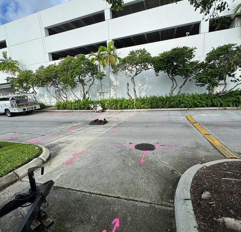
Sites near Boca Raton Airport and the surrounding commercial and industrial properties add their own private distribution and access constraints. We handle both the same way. Designate the full limits with EM and GPR, reduce the result to a list of crossings and conflicts, and place test holes only where a measured elevation changes a decision. Vacuum excavation keeps the disturbance to the footprint of the hole, with a vac truck or air and barrel soft dig depending on access and surface, and the hole is backfilled and restored in kind. Buildings stay occupied, parking stays open and the finished deliverable carries QL-D records, QL-B designated alignments and QL-A measured points on the same drawing, each labelled for what it is.
Frequently Asked Questions — SUE in Palm Beach County
Will 811 mark the utilities inside a campus or office park?
No. The 811 system notifies member utility owners, and those owners mark their own facilities up to the point of service. Everything past that point belongs to the property owner: site electrical distribution, private fire and domestic water, irrigation and reclaimed lines, site lighting circuits, private storm and the communications laterals feeding each building. Private utility locating is the mechanism that covers them, and on a campus that is most of the site.
Can you scan a post-tensioned slab before we core it?
Yes. Ground penetrating radar scanning of concrete is part of what we do, and on post-tensioned construction it is the step that keeps a core from becoming a structural repair. We scan at the intended location and mark tendons, reinforcing and embedded conduit on the surface, so the layout can be shifted before anyone drills. It is worth bringing us in while the penetration locations are still adjustable rather than after they are fixed.
Who holds the utility records for a Boca Raton site?
It depends on the facility. The city operates its own water and wastewater systems across much of its service area, so those records come from the city rather than a county authority, while electric, gas and telecom each hold their own. A campus or corporate property adds a private owner with its own drawings. We request from each, plot the result on one base and label it Quality Level D until it has been designated in the field.
Why Work With Us in Palm Beach County
- Private and campus systems: We locate the distribution behind the point of service on Boca Raton campuses and corporate properties, which 811 does not cover.
- Concrete scanning included: Ground penetrating radar scans post-tensioned slabs and decks before coring on Boca Raton buildings, using the same equipment we run in the ground.
- Multiple record sets reconciled: City water and wastewater records, separate electric, gas and telecom owners and private campus drawings are compiled onto one QL-D base.
- Depth from test holes only: Locating gives horizontal position, and measured elevations come from vacuum-excavated test holes because GPR depth drifts with the South Florida water table.
- Restoration on occupied sites: Vacuum excavation keeps disturbance to the footprint of the hole on landscaped and paved Boca Raton properties, with the surface restored in kind.
Related: how SUE works · utility mapping deliverables · QL-A test holes · SUE across Palm Beach County