What Is Ground Penetrating Radar (GPR) Scanning?
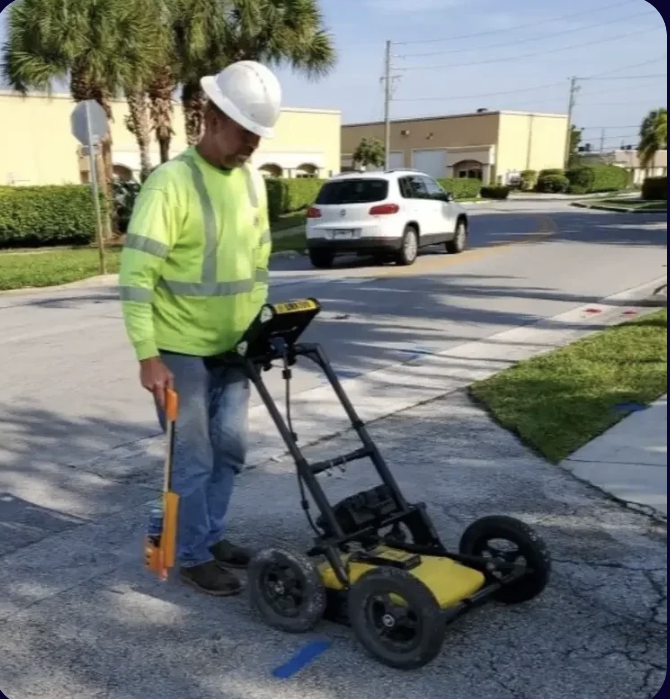
Ground Penetrating Radar (GPR) is a non-destructive subsurface imaging technology that transmits high-frequency electromagnetic pulses into the ground or concrete and records the reflections from buried objects and layer boundaries. The resulting data produces a cross-sectional profile of the subsurface, allowing trained technicians to identify the location, depth, and in many cases the material type of buried utilities, structural elements, and anomalies.
Unlike electromagnetic (EM) locating — which requires a conductive signal path and cannot detect non-metallic utilities — GPR detects any material with a dielectric contrast relative to its surroundings. That means plastic PVC water mains, HDPE gas lines, concrete storm structures, fiber conduit without tracer wire, and post-tension cables are all visible with GPR where EM finds nothing.
US Utility Potholing deploys professional GPR scanning services throughout South Florida, from urban Miami-Dade corridors to commercial developments in Palm Beach County and infrastructure projects across Broward County.
GPR Scanning Applications in South Florida
Our GPR scanning services cover a broad range of field applications for civil engineers, general contractors, municipalities, and utility companies:
- Underground utility detection: Identifying non-conductive and metallic utilities in congested South Florida utility corridors before excavation or boring.
- Concrete scanning: Locating rebar, post-tension cables, conduit, and voids within concrete slabs, walls, and bridge decks before core drilling or saw-cutting.
- Void detection: Identifying subsurface voids, sinkholes, and soil anomalies — particularly relevant in South Florida's karst and limestone geology.
- Pavement and road base assessment: Evaluating layer thickness, delamination, and subgrade conditions for road rehabilitation projects in Broward and Miami-Dade.
- Pre-bore clearance: HDD and directional boring clearance scanning to verify the bore path is free of conflicting utilities.
- Environmental site assessments: Identifying buried storage tanks, debris, and subsurface features for Phase II ESA or brownfield redevelopment projects.
- Utility depth verification: Confirming depth of critical utilities before construction activities that require verified clearances per project specifications.
Why GPR Is Essential in South Florida's Utility Environment
South Florida's construction environment presents unique challenges. Decades of uncoordinated utility installations across Broward County, Miami-Dade, and Palm Beach County have left a complex web of overlapping utilities — many of them private, many without accurate as-built records, and many installed in non-standard materials or without tracer wire.
Florida's shallow water table and sandy soils are generally favorable for GPR propagation. However, the dense urban utility corridors in cities like Miami, Fort Lauderdale, and Boca Raton require experienced interpreters who understand South Florida's utility installation history and can differentiate signal hyperbolas from known utility types, pavement layers, and soil moisture variations.
Our technicians are trained specifically in South Florida subsurface conditions. We don't just operate the equipment — we interpret the data accurately and provide actionable deliverables your engineering team can rely on.
GPR as an Underground Utility Scanner and GPR Pipe Locator
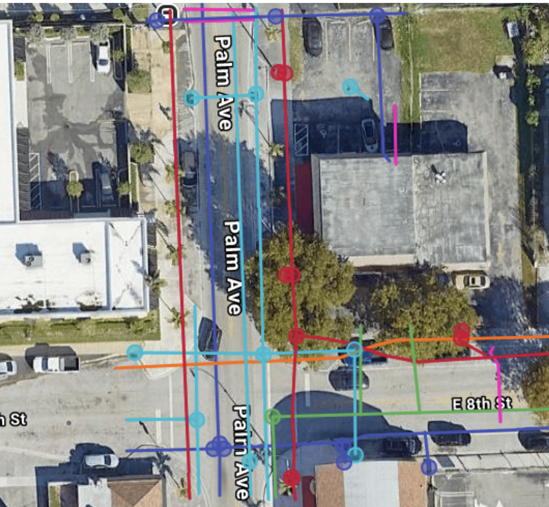
When engineers and contractors search for an underground utility scanner or a GPR pipe locator in South Florida, they need a system capable of detecting all utility types — not just the metallic lines that EM equipment can trace. Our GPR equipment functions as a full ground penetrating radar utility locating platform, detecting plastic PVC water mains, HDPE gas lines, concrete storm structures, and fiber conduit running without tracer wire. This capability is what makes GPR utility mapping a critical component of any serious subsurface investigation in Broward, Miami-Dade, and Palm Beach counties. We combine GPR data with EM locating results to produce a complete, defensible picture of what's underground before a single shovel hits the ground.
GPR + Utility Locating: The Complete Approach
For maximum coverage, we integrate GPR scanning with electromagnetic (EM) utility locating on every applicable project. EM locating excels at tracing conductive utilities with high accuracy and depth resolution. GPR fills the gap by imaging non-conductive lines, detecting masses and voids, and providing a visual cross-section of the entire subsurface profile.
When our GPR scan identifies a utility of interest, we coordinate with our vacuum excavation potholing crew to physically expose and verify the utility's exact depth, size, and material — delivering Quality Level A data per ASCE 38-02 for your SUE mapping deliverables.