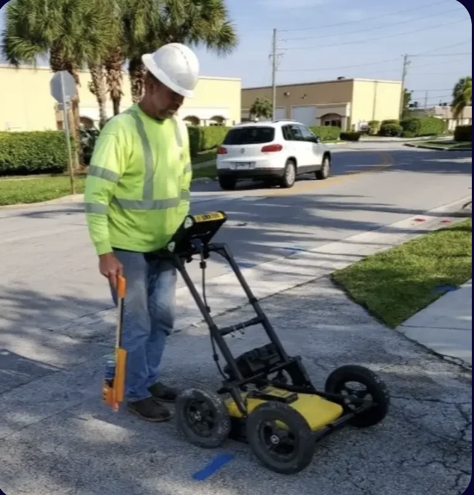
What Is GPR Scanning?
Ground Penetrating Radar (GPR) is a non-destructive subsurface investigation method that uses pulsed electromagnetic energy to image underground objects and conditions without excavation. A GPR antenna transmits energy pulses into the ground; when those pulses encounter a boundary between materials with different dielectric properties — such as the interface between soil and a pipe — some of the energy reflects back to the antenna. The return signal is processed and displayed as a radargram showing the depth and lateral position of the reflecting object.
In the context of utility locating, GPR is the critical complement to electromagnetic (EM) locating. EM equipment requires a conductive path — it works well on metallic pipes, live electrical conduit, and cables. But much of South Florida's underground utility infrastructure is non-conductive: HDPE water mains, PVC sewer lines, concrete storm drainage, fiber optic conduit, and abandoned clay pipe all lack the conductivity that EM needs. GPR detects all of them.
GPR Utility Locating — What GPR Finds
In South Florida construction and utility work, GPR scanning is used to detect:
- HDPE water mains and force mains (non-conductive, invisible to EM)
- PVC sewer laterals and drain lines
- Concrete storm drainage structures and culverts
- Fiber optic conduit and non-metallic telecom infrastructure
- Abandoned utilities left in place (old clay pipe, decommissioned conduit)
- Underground storage tanks and buried structures
- Voids, sinkholes, and subsurface anomalies
- Concrete rebar, post-tension cables, and embedded conduit (concrete scanning)
When combined with EM locating, GPR provides the most comprehensive subsurface picture available without excavation — covering both conductive and non-conductive underground features across your entire project area.
GPR Scanning in South Florida — Soil Conditions
South Florida's subsurface conditions present specific challenges and advantages for GPR scanning. The shallow, sandy soils common throughout Broward and Palm Beach County generally allow good GPR signal penetration, providing clear images at utility depths of 3–15 feet. Miami-Dade County's oolitic limestone formations at shallower depths require more careful interpretation but GPR remains highly effective for utility detection in these conditions.
The primary challenge for GPR in South Florida is the high water table. Saturated soils absorb GPR signal energy, reducing effective penetration depth. In areas with very high water tables, GPR is most effective at shallower depths — which, fortunately, is where most utility infrastructure is located. Our technicians are experienced in interpreting GPR data in South Florida's specific soil and water table conditions.
GPR Scanning West Palm Beach & Palm Beach County
In Palm Beach County and the West Palm Beach area, GPR scanning is increasingly in demand for commercial development, municipal infrastructure, and FDOT District 4 projects along US-1, I-95, Southern Boulevard, and the Okeechobee Boulevard corridors. Our GPR scanning service covers all of Palm Beach County — from Boca Raton and Delray Beach in the south through West Palm Beach and Lake Worth Beach to the Treasure Coast communities to the north.
GPR pipe locating in West Palm Beach is a key application — the city's utility infrastructure includes many non-conductive mains installed during the build-out of its water and sewer system that are difficult or impossible to locate with EM alone. Our Palm Beach County utility locating service routinely includes GPR scanning for this reason.
Frequently Asked Questions — GPR Scanning
How accurate is GPR utility locating?
GPR utility locating provides horizontal position accuracy typically within 6–12 inches under good conditions. Depth estimates from GPR are less precise — typically accurate to ±10–15% of depth — because depth calculation depends on the assumed signal velocity in the soil, which varies with soil type and moisture content. For applications requiring precise depth data, GPR locating should be followed by vacuum excavation potholing to physically confirm the utility position. This is standard practice for SUE Quality Level A work.
Is GPR scanning the same as an underground utility scanner?
Yes — GPR scanning equipment is the type of underground utility scanner most commonly used by professional utility locating companies for subsurface utility investigation. Consumer-grade "pipe locators" and ground-penetrating devices exist, but professional GPR scanning systems used by utility locating companies provide significantly better resolution, greater depth penetration, and more reliable results than consumer equipment. When searching for an underground utility scanner in South Florida, look for contractors using professional-grade systems.
Do you provide GPR scanning reports?
Yes. For GPR scanning projects, we provide field markings and, upon request, a written report documenting detected features with GPS-referenced positions, estimated depths, and interpretive notes. For SUE projects, GPR results are incorporated into Quality Level B designating reports per ASCE 38-02. Contact us to discuss the specific deliverables you need for your project.